
BlueCap Australia
BlueCapRTK® Geodetic-Grade Positioning for Drone Surveys
BlueCapRTK® is BlueCap's in-house geodetic-grade RTK system for large-area drone surveys — 8 mm + 1 ppm horizontal and sub-centimetre vertical, engineered for bush, desert and mining sites.

In-house RTK · 8 mm + 1 ppm · five constellations · one sub-microsecond timebase · every line re-processable
BlueCapRTK® is the positioning backbone of every BlueCap survey — an RTK system developed in-house for real large-area drone surveys. It is optimised for the conditions BlueCap actually operates in: remote bush, open desert and working mining sites, far from CORS networks and mobile coverage. Innovative correction algorithms run on both ends of the link — on the BlueCap base station and on the helicopters themselves — and together they hold survey-instrument accuracy: 8 mm + 1 ppm horizontal and sub-centimetre vertical. Like all BlueCap systems, it is operated by BlueCap crews and is not sold or leased separately.
Geodetic-grade numbers, held in production
These are survey-instrument figures that BlueCap's QA holds in production — the accuracy the processing chain actually receives, not a best-case laboratory quote.
Sub-centimetre horizontal positioning maintained across large survey blocks and long baselines.
Sub-centimetre discipline in height — the axis that decides whether a terrain model can be trusted, and the one most systems quietly drop.
GPS, GLONASS, Galileo, BeiDou and QZSS on the base and on every rover. What sets the solution is not what each end sees alone but how many satellites the two share — BlueCapRTK® routinely holds more than twenty in common.
The aircraft clock is disciplined by the receiver's own pulse-per-second signal, so payload samples and positions sit on one timebase. At survey speed a tenth of a second of clock error drags every reading metres along the line — this removes that error class entirely.
RTCM corrections reach every rover in well under a second, with per-constellation delivery monitored live. An ageing correction stream is the first thing the crew sees, not the last.
Raw observations and broadcast ephemerides are logged on the base and on the aircraft, so any line can be re-solved forward and backward after landing — recovering centimetre accuracy over stretches where the live link could not.
BlueCap's correction algorithms run on the base station and on each helicopter, refining the solution at both ends of the link instead of trusting a stock receiver profile.
Self-contained operation for bush, desert and mining environments — no CORS network, no mobile coverage and no survey-day compromises required.
The system in the field
One BlueCapRTK® base station commands the positioning of every helicopter on site. The base is established over a controlled point, runs BlueCap's correction algorithms locally and streams corrections over an encrypted link — while each rover on board refines its own solution against them in real time and feeds the fixed position straight into the flight controller and into every payload record.
Geodetic base station
Established over a controlled point, tracking five constellations, broadcasting its surveyed coordinate and full-constellation corrections at one hertz.
Encrypted correction link
Corrections travel over BlueCap's own encrypted network — no mobile coverage required — with age and per-constellation delivery watched live at both ends.
Rover on board every helicopter
Each aircraft resolves an RTK-fixed solution against the shared satellites and writes it into the LiDAR, magnetic and radiometric records as they are acquired.
One timebase for position and payload
The receiver's pulse-per-second signal disciplines the aircraft clock to sub-microsecond accuracy, so every payload sample carries a timestamp on the same axis as its position.

The whole RTK chain, controlled remotely
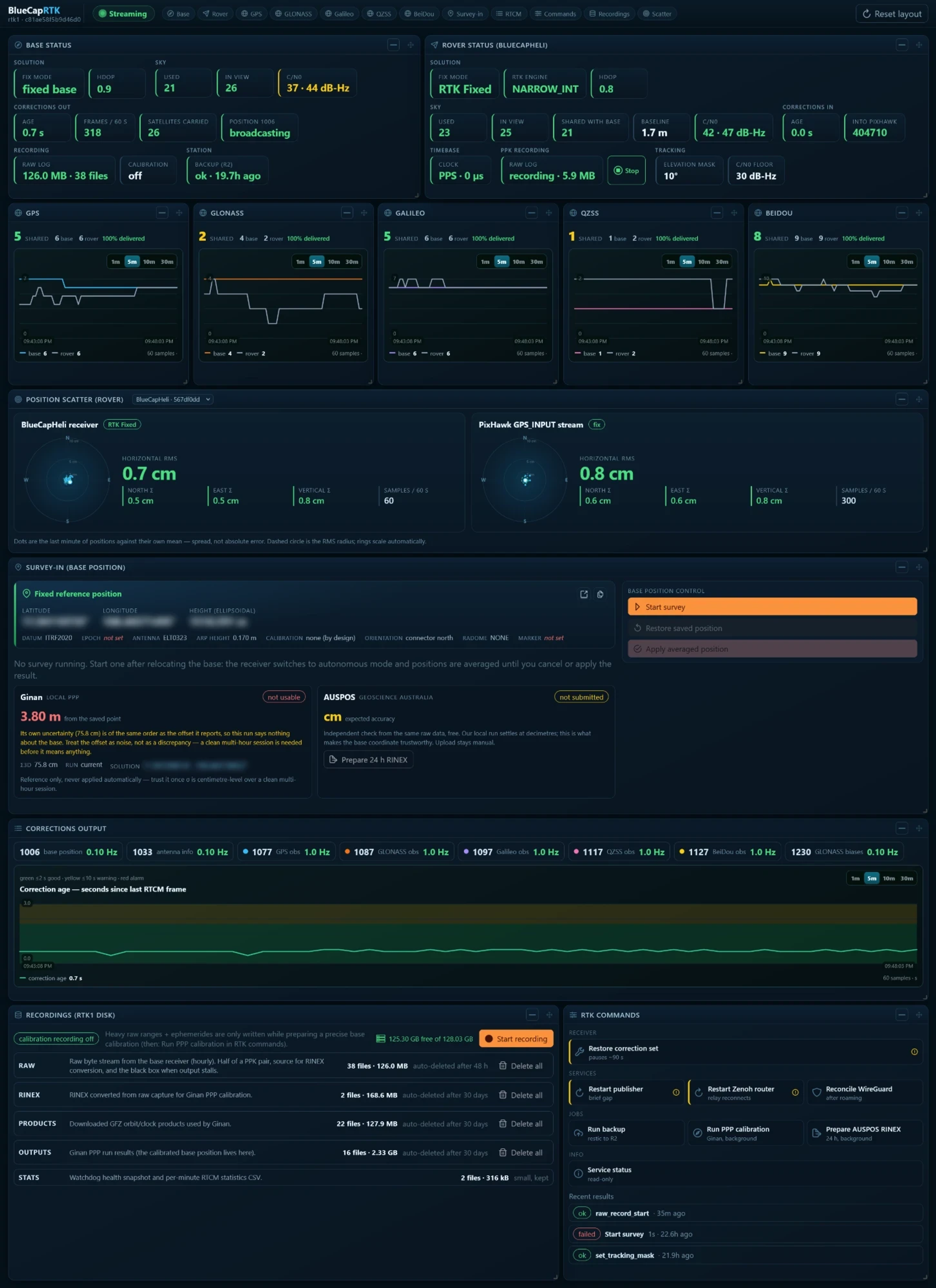
This is a live example of the BlueCapRTK® control system, developed in-house alongside the hardware. It is operated remotely, away from the equipment, over an encrypted channel — BlueCap engineers monitor and command a base station standing in the bush or on a mine site from anywhere, without touching the receiver. Every layer of the positioning chain is visible and actionable in one screen: if something drifts, the crew sees it during acquisition, not after.
What most positioning systems never show is on this screen: both ends of the link, side by side. The base and the rover report the same quantities — fix mode, satellites, signal quality — and between them sits the number that actually decides the solution: how many satellites the two share. Below it, the age of corrections as they land on the aircraft and the delivery rate of every constellation. A base can look perfectly healthy while nothing reaches the helicopter; here that is one glance during acquisition, not a discovery after landing.
LiDAR inherits every trajectory error
A LiDAR return is only as accurate as the trajectory it was measured from. Centimetres of RTK drift become centimetres of terrain error across the whole map. BlueCapRTK®'s sub-centimetre horizontal and vertical solution is why BlueCapLidar® terrain products stay maximally accurate and defensible.
Height is the hard axis
Vertical is where consumer RTK degrades first — and vertical is exactly what DTM fidelity, volume calculations and flood or infrastructure design depend on. BlueCapRTK® holds vertical at survey-instrument grade — sub-centimetre in live flight.
One position for every sensor
The same geodetic solution is written into the LiDAR record, the magnetic record and the radiometric record, so every product from a BlueCap survey shares one defensible positioning basis.
Measurement you can defend
Accuracy is a claim — verification is what turns it into evidence. Exploration data ends up in front of geologists, auditors and resource models, so BlueCapRTK® is built so that every coordinate it produces can be traced, re-derived and challenged.
Base coordinate independently checked
The base position is not taken on faith from a quick average. Long-session observations are solved against national precise-point services, giving the whole survey an absolute anchor that a third party can verify from the same data.
Survey metadata carried with the coordinate
Datum, epoch, antenna model, reference-point height and orientation travel with the base position — the questions a surveyor asks first are answered in the record, not reconstructed from memory months later.
Raw data outlives the flight
Both halves of every PPK pair — base and aircraft observations with ephemerides — are archived. Any line from the survey can be re-solved years later with better products, or handed to a client's own geodesist for audit.
Geodetic grade against built-in drone RTK
Integrated drone RTK — the class fitted to DJI Matrice-type aircraft with a portable base such as D-RTK 2 — is designed for photogrammetry convenience, not geodetic measurement. The comparison below is about positioning quality: the class of receiver, the accuracy specification and how each system behaves on a real large-area survey.
| Capability | BlueCapRTK® | Typical built-in drone RTK (Matrice-class) |
|---|---|---|
| Horizontal accuracy, specification | 8 mm + 1 ppm — survey-instrument class, held in production QA | 10 mm + 1 ppm — consumer-module claim, quoted for ideal conditions |
| Vertical accuracy, specification | 10 mm class — survey-instrument grade, held in production QA | 15 mm + 1 ppm — optimistic for a moving airframe in field conditions |
| Vertical error 10 km from the base | ≈ 10 mm — long-baseline algorithms hold the solution across 30 km blocks | ≈ 25 mm and growing — photogrammetry-class baselines, error compounds with every kilometre |
| Timestamp error in the data at 35 m/s | < 0.1 mm along track — aircraft clock disciplined to the receiver's pulse-per-second signal | 0.7–3.5 m along track — payload timestamps ride a flight-controller clock 20–100 ms adrift |
| Satellites in the solution | 5 constellations tracked at both ends, 20+ satellites shared between base and rover | 3–4 constellations; shared-view count invisible to the operator |
| Correction stream in flight | 1 Hz, age under 1 s, delivery of every constellation monitored live at both ends | Status icon only — a silent dropout surfaces in the data, after the flight |
| Raw data kept per survey line | 2 full observation logs — base and aircraft, re-processable forward and backward, auditable by a third party | 0 — what the live link produced is what the survey keeps |
| Base coordinate confidence | 5–10 mm — long-session solution checked against national precise-point services | Metre-class — brief self-average of a portable base |
| Operating environment | Self-contained for bush, desert and mine sites — no CORS, no mobile coverage required | Designed around typical commercial-site conditions |
| Role in the survey | One positioning basis written into LiDAR, magnetic and radiometric records | Positioning for the aircraft's own camera products |
Two of those rows decide real surveys. Timing: at 35 m/s survey speed, a payload timestamp riding a flight-controller clock 20–100 ms adrift smears every sample 0.7–3.5 m along the line — three orders of magnitude larger than the RTK error itself. BlueCapRTK® pins the clock to the receiver's pulse-per-second signal, so the timing contribution is under a tenth of a millimetre. The base coordinate: every track inherits it whole. A metre-class self-averaged base shifts the entire survey by that metre no matter how good the RTK is; BlueCapRTK® anchors it to 5–10 mm against national precise-point services.
The difference is not academic: on a LiDAR survey the RTK solution is the map's accuracy ceiling. Survey-instrument positioning is what allows BlueCap to publish terrain products that hold up against ground control — without a re-survey.
Related systems: BlueCapHeli® carrier, BlueCapLidar® terrain payload, BlueCapBird® quantum magnetometer and the drone LiDAR survey service.
Project enquiry
Let’s plan your survey
Start with your survey area and the data you need. We’ll help define the scope, review terrain-aware 2D and 3D flight plans, and keep field progress, processed data and deliverables together in the BlueCap Survey Portal.
No software subscription fee for BlueCap service projects.
