
BlueCap Australia
Environmental site screening: turn uncertainty into focused questions
Turn uncertain ground into focused next questions while keeping contamination, radiation and clearance decisions with the right specialists.

Screening brings together records, maps, imagery and carefully selected observations to decide what needs closer attention. It can identify patterns, gaps and locations worth investigating, but it does not prove that a site is clear, safe, remediated or compliant.
For contamination assessment, Australia's Assessment of Site Contamination NEPM places a conceptual site model, data-quality objectives and an appropriate sampling and analysis plan at the centre of the work. Screening can help shape those next steps; it cannot replace them.
Match the observation to the concern
Turn incomplete site history into a practical next investigation.
Useful outputs to discuss
- An evidence register for plans, imagery, reports and field observations
- Annotated anomaly, terrain-change or historic-feature maps with confidence notes
- Clear next steps for the relevant contamination, radiological, locating or rehabilitation specialist
Build the context
Bring together historic use, proposed land use, records, imagery and known constraints.
Ask one clear question
Separate ferrous anomalies, non-ferrous/EM questions, natural gamma context and terrain change.
Escalate proportionately
Use the map to target the specialist investigation, sampling or verification that the decision requires.
Start with the specific question
A useful review may ask whether records suggest former tanks, workshops, dumping, extraction, fill or altered drainage; where a walkover or targeted investigation should focus; whether terrain or vegetation cover has changed; or what a particular magnetic, EM or gamma response actually indicates.
Locating likely buried steel before planning boreholes is a different task from assessing soil contamination, verifying rehabilitation or assessing potential radiation exposure. Keep the output attached to the stated decision.
Question one: are there mapped ferrous-object anomalies?
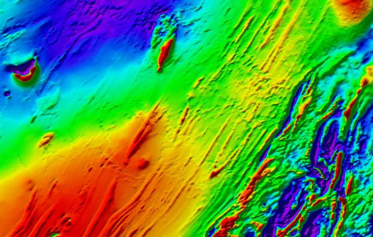
A magnetic survey measures small changes in the Earth's magnetic field. Ferrous material, especially iron and steel, can produce recognisable anomalies, so magnetic data can help map areas that may contain tanks, drums, pipes, utilities or other ferrous objects. The result is an anomaly map, not an object identification. Its location, shape and strength can be affected by material, orientation, depth, nearby metal, geology, layout and processing. US EPA explains the method and its interpretation limits.
Magnetics is not a general “metal scan”. It may not reveal non-ferrous aluminium, copper, brass or lead, and an absent anomaly does not demonstrate that infrastructure, waste or contamination is absent. Where the question includes non-ferrous conductive material, a specialist EM or metal-detection approach may be more relevant; that response is still indirect and can be limited by target, depth and clutter. See US EPA's EM metal-detector guidance.
Plain-English takeaway: a mapped magnetic anomaly means there is a measurable magnetic difference here. It does not mean “this is definitely a tank”, “all buried metal has been found”, or “the area is cleared”.
Question two: what does a natural gamma response mean?
Near the ground surface, naturally occurring potassium, uranium and thorium in rock and soil account for almost all gamma rays normally measured by gamma-ray spectrometry. Their patterns can help with geological and near-surface mapping, including changes in soil, lithology and drainage. Geoscience Australia provides the Australian method context.
A gamma pattern is not automatically contamination or a radiation hazard. Natural background varies with geology and soil, and field conditions, survey height, moisture, cover and configuration affect the result. If site history, material or a measured response creates a radiological question, the scope needs an appropriately qualified radiation specialist and relevant regulator. A generic map is not a dose assessment, radiation-safety determination or clearance decision. ARPANSA's NORM safety guide describes a graded, context-specific management approach.
Martin and co-authors reported UAS radiation mapping at legacy uranium mines. Read the 2015 study. It is a specialist radiological case with a defined site context, not evidence that ordinary drone imagery or broad screening establishes radiation safety.
Question three: has terrain or rehabilitation changed?
Comparing dated imagery, elevation data, drainage patterns, plans and field observations can highlight new or removed stockpiles, pits, bunds, drains or tracks; erosion features; altered vegetation cover; and differences between planned and observable landform. It can prioritise a walkover or current survey control.
It does not prove rehabilitation performance. Imagery can differ by season, cover, illumination, resolution and capture timing; apparent change can be an acquisition difference rather than ground movement. Record source, date, scale, observed change, confidence and what ground evidence would confirm or contradict it.
A useful screening deliverable
- scope, decision statement, boundary and exclusions;
- evidence register with source, date, coverage, limitation and relevance;
- annotated maps of observations, anomaly areas, historic features and access constraints;
- observation register with location, alternatives, confidence and follow-up;
- conceptual-site-model inputs and data gaps; and
- a limitations statement and proportionate next-step plan.
Worked example: former depot before redevelopment
Historic plans show a workshop and possible fuel-storage area; a magnetic grid shows clustered anomalies near it; recent imagery shows regrading and changed drainage. A defensible interpretation is that the anomalies are locations to investigate for ferrous objects or infrastructure, that non-ferrous services or waste could still be present, and that landform change needs ground verification. That can shape a conceptual site model and targeted next work. It cannot establish uncontaminated ground, safe excavation or suitability for redevelopment.
What screening does not provide
Screening does not provide site-suitability certification, contamination assessment, remediation validation, regulatory sign-off, utility or excavation clearance, identification of every buried object, proof contamination is absent, a dose assessment, radiological clearance or confirmation that rehabilitation criteria have been achieved.
Briefing checklist
- site boundary, access and proposed future land use;
- current and historic plans, imagery, photographs and development records;
- known uses, incidents, fill, waste, tanks, services, extraction or rehabilitation work;
- prior environmental, geotechnical, geophysical or radiological reports;
- the precise question: ferrous, non-ferrous, terrain change, gamma context or another issue;
- coverage, positional needs, access and sensitive-receptor constraints; and
- applicable regulator, auditor or specialist requirements.
References and next reading
- National Environment Protection Council: Assessment of Site Contamination NEPM. Australian framework implemented through jurisdictions.
- US EPA: Magnetic Method and EM metal-detector methods. General method guidance, not a clearance standard.
- Martin, P. G. et al. (2015), “The use of unmanned aerial systems for the mapping of legacy uranium mines”, Journal of Environmental Radioactivity 143, 135–140. DOI: 10.1016/j.jenvrad.2015.02.004. Specialist legacy-mine case only.
Return to Choose a survey, see infrastructure site investigation, flood, erosion and terrain, magnetic, LiDAR and radiometric method information, read about drone surveying services from BlueCap, or discuss a project question.
Project enquiry
Let’s plan your survey
Start with your survey area and the data you need. We’ll help define the scope, review terrain-aware 2D and 3D flight plans, and keep field progress, processed data and deliverables together in the BlueCap Survey Portal.
No software subscription fee for BlueCap service projects.
